 Dronelix
Part 107 chart reading
What does a dashed blue circle mean on a sectional chart?
It marks a Class D boundary. On this fictional training chart, the ring surrounds Marlow Muni. The boxed 27 gives its ceiling in hundreds of feet above mean sea level: 2,700 feet MSL.
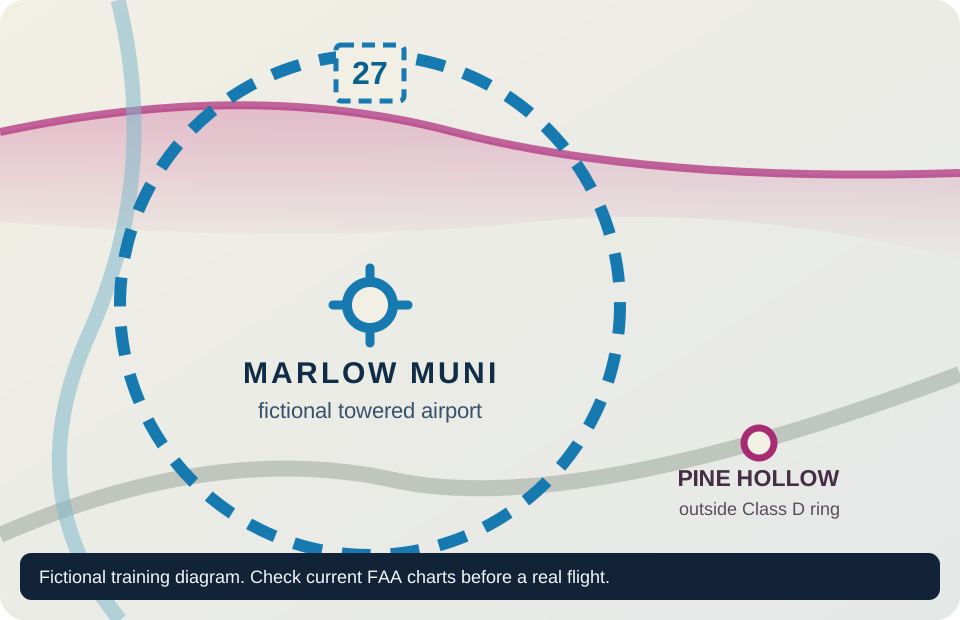
For a Part 107 flight inside that active Class D area, get prior ATC authorization. The blue ring tells you where Class D is. The 27 tells you the ceiling; it is not a radius or a frequency.
Class D surface area around the towered airport. A Part 107 flight within it needs prior ATC authorization under 14 CFR 107.41.
The charted Class D ceiling is 2,700 feet MSL. The number is in hundreds of feet, and MSL is measured from sea level.
Try the question from Dronelix
This is question faa107-air-061 from the app's Part 107 airspace bank. Choose an answer, then read the reason.
Show the answer and FAA sources
First answer. A dashed blue circle is a Class D surface area, and the blue airport symbol inside it marks a towered field. 14 CFR 107.41 requires prior ATC authorization for a Part 107 operation in Class B, C or D airspace, or within the lateral boundaries of a Class E surface area designated for an airport.
The magenta shading is a different clue. In this training scene it marks a Class E floor at 700 feet AGL, not a Class E surface area. Check the FAA Aeronautical Chart Users' Guide and AIM 3-2-5 for the chart convention and Class D description.
Use a current chart for an actual flight
This drawing is an exam exercise, with fictional airports and simplified boundaries. A real operation needs current aeronautical information and any required authorization. The FAA publishes chart guidance and Part 107 authorization instructions.
Keep practising
Try ten free Part 107 questions
All 402 questions in the app's Part 107 track are free to study, with explanations and citations. The full length timed mock exams are an optional one time purchase.
Dronelix is an independent study app from IOCODO LLC and is not affiliated with the FAA.